- สมัครเมื่อ
- 7 กันยายน 2023
- โพสต์
- 111

ดาวน์โหลด ปลั๊กอิน Land4 29.05.02 beta for ArchiCAD 29 เวอร์ชั่นล่าสุด ปลั๊กอินออกแบบภูมิสถาปัตยกรรมระดับพรีเมียมที่เปลี่ยน Archicad ให้เป็นเครื่องมือจัดการภูมิประเทศและงาน Landscape ที่ทรงพลังที่สุด ฟรี
LAND4 for Archicad คือปลั๊กอิน (Add-on) ระดับมืออาชีพที่ออกแบบมาเพื่อสถาปนิกและภูมิสถาปนิกที่ต้องการข้ามขีดจำกัดเดิมๆ ของ Archicad ในการจัดการงานภูมิประเทศ (Topography) และพื้นที่ภายนอกอาคาร โดย LAND4 จะเข้ามาเปลี่ยนกระบวนการทำงานที่เคยยุ่งยากให้กลายเป็นระบบอัจฉริยะที่ช่วยในการสร้าง ปรับแต่ง และจัดการข้อมูลภูมิประเทศในรูปแบบ BIM ได้อย่างสมบูรณ์แบบ ช่วยให้คุณสามารถทำงานวิจัยพื้นที่ (Site Analysis) และออกแบบภูมิทัศน์ที่มีความซับซ้อนได้อย่างแม่นยำและรวดเร็ว โดยยังคงรักษาความเชื่อมโยงกับโมเดลอาคารหลักไว้อย่างเหนียวแน่นครับ
จุดเด่นที่เป็นหัวใจสำคัญของ LAND4 คือระบบ LandSpot และ LandLine ซึ่งเป็นเทคโนโลยีเฉพาะที่ช่วยให้การจัดการค่าระดับ (Spot Elevations) และเส้นชั้นความสูง (Contours) ทำได้แบบไดนามิก เมื่อคุณทำการปรับปรุงความสูงที่จุดใดจุดหนึ่ง ระบบจะทำการประมวลผลพื้นผิวภูมิประเทศ (Triangulation) และอัปเดตโมเดล 3 มิติให้ทันทีโดยอัตโนมัติ นอกจากนี้ยังมีเครื่องมือ Cut & Fill ที่ช่วยคำนวณปริมาตรงานดินขุดและดินถมได้อย่างแม่นยำ พร้อมทั้งสามารถสร้างรายงานข้อมูลเพื่อนำไปใช้ในการประเมินราคาก่อสร้างได้อย่างเป็นมืออาชีพ
ในด้านการทำงานร่วมกับเทคโนโลยีสมัยใหม่ LAND4 รองรับการนำเข้าข้อมูลจากแหล่งต่างๆ เช่น ไฟล์สำรวจพื้นที่ (Point Files), ไฟล์จากโดรน หรือข้อมูลจากระบบสารสนเทศภูมิศาสตร์ (GIS) เพื่อนำมาสร้างเป็นโมเดลพื้นผิวที่สมจริงที่สุด ตัวปลั๊กอินยังได้รับการออกแบบให้อินเทอร์เฟซกลมกลืนไปกับ Archicad ทำให้ผู้ใช้งานสามารถเรียนรู้ได้เร็วและไม่ขัดต่อเวิร์กโฟลว์เดิมที่มีอยู่ หากคุณกำลังมองหาวิธีการยกระดับงานภูมิสถาปัตยกรรมจากภาพวาด 2 มิติ สู่โมเดล BIM ที่มีข้อมูลครบถ้วนและแม่นยำ LAND4 คือเครื่องมือที่จะช่วยปิดช่องว่างและเพิ่มศักยภาพในการแข่งขันให้กับโปรเจกต์ของคุณได้อย่างแท้จริง
คุณสมบัติเด่น (Key Features)
- Dynamic LANDSurface: สร้างพื้นผิวภูมิประเทศ 3 มิติที่ชาญฉลาด โดยพื้นผิวจะอัปเดตโดยอัตโนมัติเมื่อมีการแก้ไขจุดระดับ (Spot Levels) หรือเส้นขอบเขต (Ridge Lines)
- Spot Level & Interpolation: เครื่องมือวางจุดระดับที่รองรับการคำนวณความสูง (Interpolation) แบบ 2 จุด, 3 จุด หรือตามค่าความชัน (Gradient) ที่กำหนด
- Automated Volumetrics: คำนวณปริมาณงานดินขุด-ดินถม (Cut and Fill) ได้ทันที พร้อมสร้างตารางสรุปปริมาตรที่แม่นยำสำหรับงานก่อสร้าง
- Drape Function: ฟังก์ชัน "วางแนบ" ที่ช่วยให้วัตถุใน Archicad (เช่น ต้นไม้, เฟอร์นิเจอร์, เสา) วางอยู่บนพื้นผิวภูมิประเทศที่คดเคี้ยวได้อย่างพอดี และขยับตามหากมีการปรับระดับดิน
- LAND4 Composites: สามารถกำหนดวัสดุโครงสร้าง (Building Materials) ให้กับพื้นผิวดิน เพื่อแสดงรายละเอียดในหน้าตัด (Section) และใช้ในงาน BIM เต็มรูปแบบ
- Fall Lines & Ridge Lines: สร้างเส้นแสดงทิศทางการไหลของน้ำ (Fall Lines) และเส้นสันเขา/เส้นขอบ (Ridge Lines) เพื่อควบคุมรูปร่างของภูมิประเทศอย่างละเอียด
- Data Exchange (LandXML): รองรับการนำเข้าและส่งออกไฟล์ LandXML เพื่อแลกเปลี่ยนข้อมูลกับวิศวกรที่ใช้ Civil 3D หรือซอฟต์แวร์สำรวจอื่นๆ
- Category Management: ระบบจัดการเลเยอร์และหมวดหมู่เฉพาะสำหรับงานแลนด์สเคป ช่วยให้การจัดระเบียบโมเจลขนาดใหญ่ทำได้ง่ายขึ้น
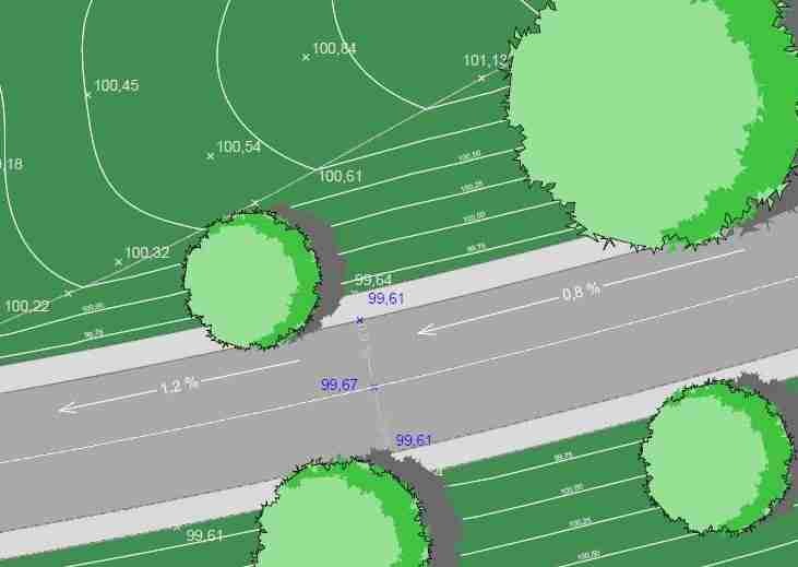
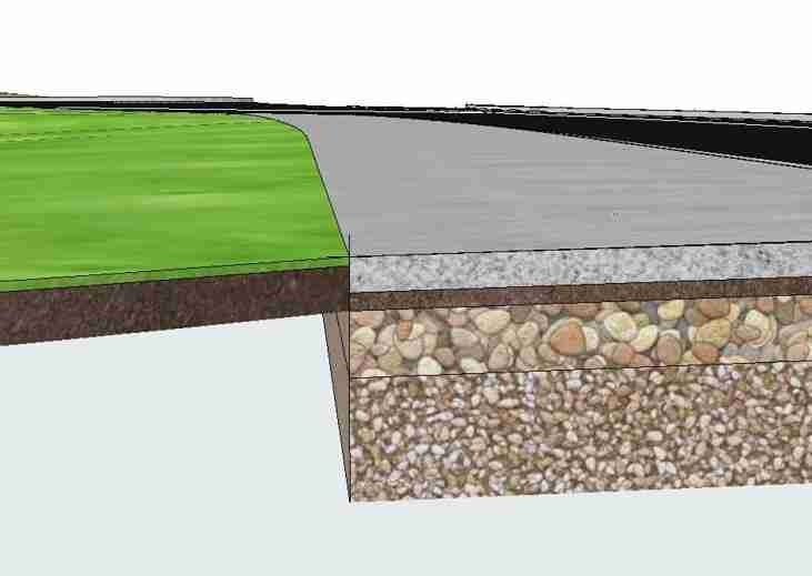
ภาพตัวอย่างโปรแกรม (Screenshots)
ความต้องการของระบบ (System Requirements)
ArchiCAD 29
File Info
Official Website : https://www.land4cad.com/
License : Trial
Software Version : 29.05.02 beta
ชื่อไฟล์ : L429.05.02ACAD29.rar
ขนาดไฟล์ : 10.4 MB
นามสกุลไฟล์ : *.rar
เซิฟเวอร์ : Pixeldrain | Box
วันที่อัพโหลด : 19/02/2026
แก้ไขล่าสุด : 19/02/2026
รหัสผ่าน : sbz
เนื้อหาเฉพาะผู้ใช้ที่ลงทะเบียนแล้ว!
รหัสแตกไฟล์คือ sbz